A Short Walk in the Afghan Pamirs
Pamir Trail founder Jan Bakker shares his story on a traverse across the Pamir Mountains on the Afghanistan side, deep in the Wakhan Corridor. This route has been added as an extension to the Pamir Trail.

Wakhi people living in harsh conditions above 4000 metres
Dushanbe, the capital of Tajikistan, was scorching hot as usual. With temperatures of over 40 degrees Celsius we did not want to waste any time here. The Toyota Land Cruisers were ready to take on the infamous Pamir Highway, a high altitude road that connects Tajikistan with southern Kyrgyzstan. It’s one of the most scenic drives in the world, but also one of the roughest as it runs right through the heart of the Pamir Mountains. It’s essentially a dirt track, despite its qualification ‘Highway’. We were headed in a slightly different direction, towards a thin slice of land wedged between two formidable mountain ranges: the Wakhan Corridor.
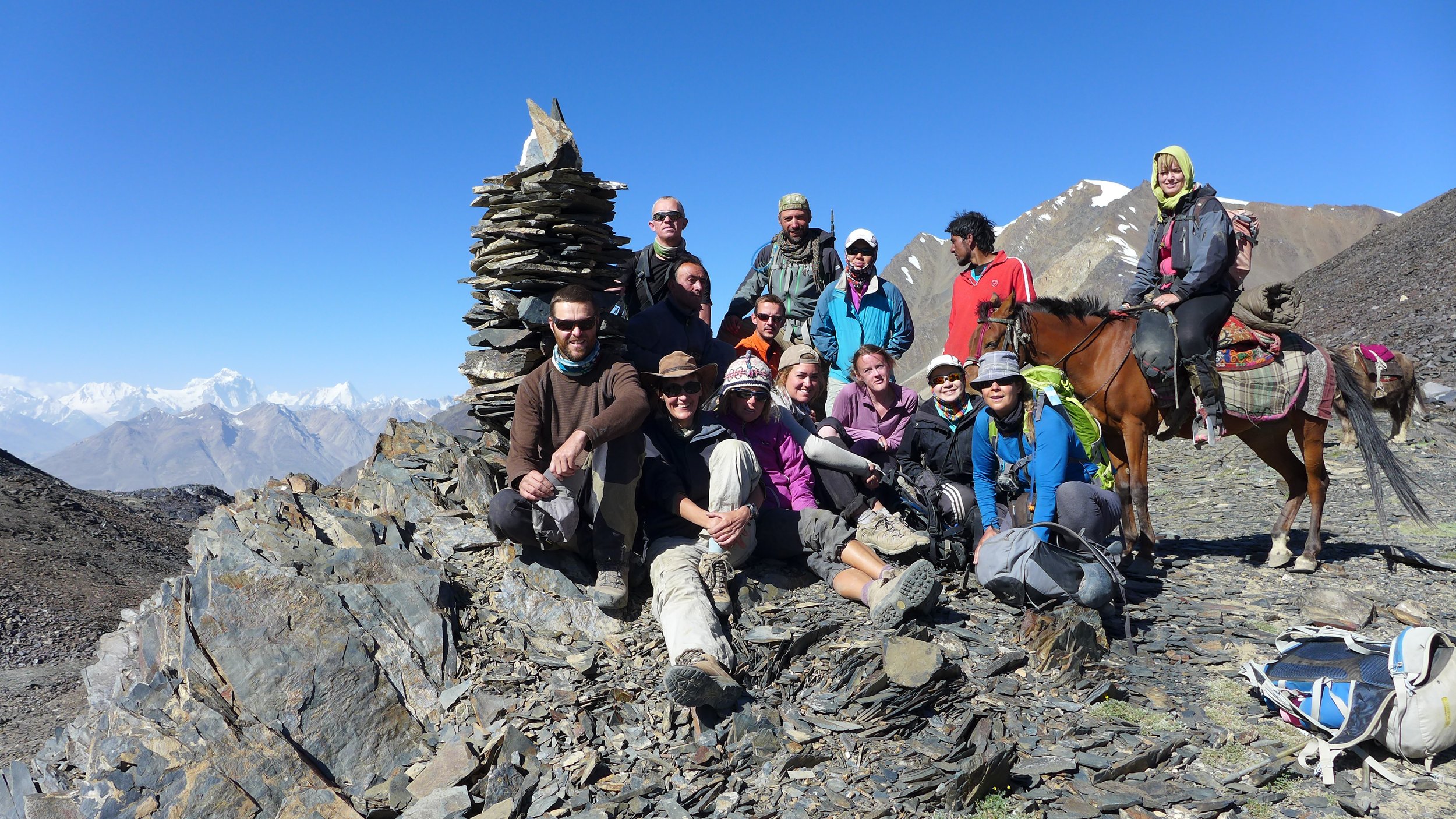
Along with fellow group leader Luca, I was guiding a 12-strong team on an exploratory trek for expedition company Secret Compass. Our team aim was to trek between Afghanistan's Pamir Mountains and high altitude deserts, meeting and learning from the Wakhi and Kyrgyz shepherds who call this remote and harsh landscape home.
Our multi-national team (six nationalities!) had people from all walks of life and with varying ability levels. There were young British and Australian women, an expedition literature academic, an well-travelled Dutch couple with plenty of similarly high-altitude experience under their belts, a Singaporean lady who had summited the 8201 metre high Cho Oyu and an engineer on leave from a super yacht trying to get as far away from water as possible! They all had one thing in common. They all ventured out here to quench their thirst for adventure in this last frontier of high altitude trekking.
The Wakhan Corridor is a panhandle-shaped strip of land in the far northeast of Afghanistan. The gateway to this remote mountain region is the border town of Ishkashim. The southern border of Pakistan is guarded by the spiky, glaciated peaks of the Hindu Kush. Just 12km north of this frontier, the upper reaches of the Panj River separate the Afghan Wakhan from Tajikistan. And 300km further east is the heavily militarised border of China’s Xinjiang Province. The mountain passes which continue into the neighbouring countries are strictly off-limits which makes the Wakhan a dead-end street: one way in, one way out.

Travelling by 4X4 was certainly not a luxury option. The heavily potholed road and its rickety bridges were making the journey itself a proper adventure. Add suspicious Tajik army officers and rockfall-prone cliffs and you’ve got yourself an epic road trip. For much of the journey we followed the wild, roaring Panj River, known as the Oxus in ancient times. On the opposite side of the river we could see a dangerously exposed donkey trail carved into the vertical walls, connecting the isolated villages found in this part of Afghanistan. Our fixer got off the phone with the commander of the Afghan border post. It was Ramadan and the border police wanted to call it a day. They were tired and hungry. He managed to convince them to stay open a little longer and after an hour of hair-raising driving the Land Cruisers reached the bridge that connects Tajikistan with Afghanistan. Leaving Tajikistan was not a problem. Getting into Afghanistan proved to be a bit harder. My fellow expedition leader Luca was summoned to a small backroom where he was told that the entire border post had waited just for us, a special service. And special services have special price tags. Once the ‘privilege’ was paid for and after a quick check of our duffle bags -for alcohol and other contraband- we were good to go. Welcome to Afghanistan!

The road into the Wakhan Corridor requires 4X4
The Wakhan Corridor is steeped in history. It was one of the lesser-known Silk Road routes into China when it was still an independent kingdom, and Marco Polo described it when he travelled through the Wakhan in 1271. During the so-called Great Game era (a shadow play between Tsarist Russia and the British Empire in the 19th century) the Wakhan Corridor became the political centre of attention. The borders of the two super powers came too close for comfort and both parties agreed on the creation of the Wakhan as a buffer zone.
Malang Darya, our local guide, was a local legend, responsible for a newer slice of Afghan history. He shot to fame in Afghanistan when he and a fellow Afghan climber reached the summit of Afghanistan’s highest peak, Mount Noshaq (7492m). As part of the Wakhan Tigers, as the group of climbers called themselves, he became a symbol of hope and determination. This extraordinary feat was covered in the press nationwide and made him an instant celebrity. Wherever Malang goes, in spite of his charming and gentle character, he demands respect. While he was taking care of the local permits, I went to the Ishkashim market to arrange the food for the expedition. Following the 2013 Secret Compass expedition to the Wakhan, essential kitchen kit and equipment had been left behind in a certain guesthouse for future use. Alas this kitchen inventory had miraculously disappeared so I quickly set about locating more gas stoves, cutlery and a couple of pressure cookers. An army of adventurers marches on its stomach.

Sunset in the Pamirs
With logistics taken care of in Ishkashim we still had to drive another 200km towards Sarhad-e-Broghil, the trailhead of our trek. The road zigzagged its way up seemingly impenetrable terrain and gradually it dawned on us why the driver had planned two full days’ driving for this 200km journey. The worn-out jeeps braved enormous pits of sand and rock and the fast-flowing rivers that drain the meltwaters of the Hindu Kush. Despite all the wildness, the Wakhan Valley felt like a true Shangri-La. We passed charming settlements, where women in red robes were working the land and children were joyfully chasing our cars.
It was hard to imagine that this place is one of the most extreme habitable places on earth during winter. Temperatures can plummet to a bone-chilling minus 30 degrees Celsius and heavy snowfall can make the roads impassable for most of the winter. In summer the Wakhi work hard to make their homes ready for winter time. Life is extremely tough for the 10,000 inhabitants of this forgotten corner of Afghanistan.
Past winters can affect the summer visitor too. Last winter there had been more snowfall than usual. As a result, the raging Wakhan River as it is called on this stretch, was in places bursting its banks. At the settlement of Sargaz our vehicles could not continue anymore. The road wasn’t just flooded, it had been completely swallowed by the river. One of the drivers was almost swept away while wading in, trying to prove that we were really unable to go any further. We were lucky that Sargaz is blessed with a hot spring - an excellent spot to discuss Plan B!
Our original plan had been to end the trek in a settlement called Wuzed, just half an hour downstream from Sargaz. After contemplating pros and the cons with Malang and Luca, we decided on an apparently radical change of plan: to do the entire trek in reverse, clockwise instead of anticlockwise. The first two days would be hard, as we would gain lots of vertical metres in a short period of time. And we weren’t sure whether we would be able to arrange enough pack animals at such short notice. Malang proved his value once again - it pays to have some star power in Afghanistan. The next morning, 17 grunting yaks were eagerly waiting to haul the 895kg of food and equipment to higher elevations.
Our first day started well: after half an hour we were standing in front of a fast-flowing, chest-deep river. The yaks appeared to be immune to any current and ferried the team members to the other side. The trail then climbed steeply into a deep, bone dry-gorge that would eventually lead us to the Big Pamir plateau. When we looked over our shoulders we could see the ocean of mountains and the glaciers of the Hindu Kush laid out before us.

Yak river crossings are a thing!
As our caravan reached the first mountain pass of over 4,500m we stared into the remote interior of the Afghan Pamirs. This high altitude desert fringed by 6,000m peaks is the domain of the elusive Marco Polo sheep and its mighty arch-enemy, the snow leopard. We descended to the bottom of the valley to set up our camp next to a yurt settlement. The hospitable Wakhi inhabitants offered us an Afghan version of yak butter tea, quite similar to its Tibetan counterpart. This salty and somewhat rancid liquid is excellent, as long as you think of it as a hearty soup. Some of us were not convinced! However, after a long day of dry air and high altitude, we could definitely use some salts to recuperate from the exercise.
The next day we climbed up the Big Pamir, a dusty and windswept plateau at over 4,000m. In the north, the mountain giants of the Tajik Pamirs dominate the horizon. Our goal was to reach Manjulak, a yurt settlement tucked away in a surprisingly green, lush valley with a crystal clear glacial stream. It was hard to square this beautiful location with the Afghanistan of news reports. We entered the guest yurt for a welcoming cup of tea. Amidst the smoke of the yak-dung fire, we sat on colourful blankets and carpets, while our hosts were dressed in those striking red robes, traditional dress for Wakhi women. Outside, the sun had disappeared behind the tall ridge and instantly the air turned bitterly cold. Still, the elderly women were milking the yaks while the shepherds were coming down from higher grounds with their goats and sheep. This daily routine is gruelling, but reminds the traveller that life is tough in these remote regions.

Yurt settlement tucked away in the Afghan Pamirs
It’s not only the daily grind that make life here a challenge, however. As we progressed east we entered Kyrgyz territory. The ethnic group of around 1500 Kyrgyz nomads roam on what they call Bam-I-Dunya, or the Roof of the World. In contrast to the Wakhi, who return to lower ground at certain times of year, the Kyrgyz live permanently above altitudes of over 4000m. The only available fuel to heat the yurts in the brutal winters is dried yak dung. Due to the lack of access to medical facilities and endemic malnutrition, this part of the Wakhan Corridor has one of the highest maternal mortality rates in the world (160 of every 1000 babies do not survive birth). In 1978 the majority of the Kyrgyz population were granted asylum in Eastern Turkey after the Shaur Revolution, locally known as the “Last Exodus”. Those left here live a life close to that of their ancestors, but full of hardship. The team were delighted to meet the children of our temporary hosts, but as we handed over instant photographs of one baby or another, it was upsetting to think that, in a matter of months, the photograph might be a memento of a child no longer alive.
Leaving our gracious hosts behind, we moved on. As we skimmed the foothills of the multiple unclimbed 5000m+ peaks of the Afghan Pamirs, we could see the deep blue waters of Lake Zorkul in the distance. This striking landmark was once thought to be the source of the Oxus. The first known European to have visited this lake in modern times was Scottish naval officer and explorer John Wood in 1838. Unfortunately we didn’t have time enough to explore the lake ourselves, as we were heading for Mula, another Kyrgyz settlement, this time situated on the higher slopes of the Pamirs.

Yaks carry the big bags across the Pamirs
This was the last inhabited place we were staying at before one of the most important aims of the expedition – crossing the 4895m high Showr Pass. We settled ourselves into another cosy guest yurt. Although visitors are comparatively rare here, many villages maintain a space for them, either erecting a yurt specifically for their arrival, or asking a designated family to move in with neighbours to allow guests some space of their own. In Mula it was as if the circus had come to town. At the small entrance of the yurt a dozen Kyrgyz were pressing to catch a glimpse of what we were doing. Which in fact was: lying down in our sleeping bags, knackered from a long day’s walk. Nevertheless, it all appeared to be mighty interesting. Later in the day we learned that we had to take a compulsory (but welcome!) resting day. There were no horses - the pack animal of choice in this area - available for the next day. A delay during an expedition is normally something undesirable. However, if a game of buzkashi is the cause, there is no reason to complain!
Buzkashi is Afghanistan’s national sport and is also played in other parts of Central Asia. This game, rough and exhausting for both horses and riders, is played on a big flat and often dusty pitch. It’s ‘every man for himself’ (and it is only men), and the aim is to sink a dead headless goat's/sheep's corpse into a hole in the ground. Horsemen try to steal the corpse from a competitor and score a point. We went down to the buzkashi pitch, along with the local Kyrgyz crowd. It was as if we were going to see a football match. Our expedition chef, Inayat, turned out to have additional talents to the provision of tasty meals. He proved himself to be an excellent buzkashi player, often leaving the Kyrgyz competition in a cloud of dust. Cheering the players was not without risk. The pitch itself didn’t have any boundaries, so occasionally we had to run for our lives to avoid being trampled. It’s a spectacular and intense sport, dust flaring up around the charging horses in front of a mountainous backdrop – our rest day, initially an inconvenience, had turned out to be an expedition highlight.

The rough game of buzkashi in full action
It was day eight of the expedition and it was time to leave Kyrgyz territory. After a relatively short day of walking we set up camp at a deep blue glacial lake, close to the foot of the Shawr Pass. We were all well-acclimatised and confident the whole team would be able to scale the pass. We got up early that night so we would reach the top of the pass before the heat. Getting up in the dead of night to tackle a mountain pass or summit is magical: the anticipation of the climb itself and the incoming morning light is worth the 3am alarm call. The team huddled together at a roaring yak dung fire and tried to shove down some breakfast and then we were off. An almost invisible goat track worked its way up the pile of scree and boulders, passing more stunning lakes and tumbling glaciers. After five hours of climbing we all stood on the top of the nearly 5000m high Shawr Pass, with the sun now fully risen, taking in the views of the jagged peaks on the other side and wondering just what was supposed to be ‘little’ about the ‘Little Pamir’.

Crossing the glacier just after the Shawr Pass
The successful crossing of the pass was celebrated with a hearty meal of mutton at the settlement of Chapdara. This was a welcome addition to our daily intake, since the team were starting to feel the effects of such a lengthy stay at altitude. Despite Inayat’s lovely food we were served every day, we were burning more calories than we could put back into our systems. However, the end of the trek was now in sight. On day 11 we tackled the last pass, at 4725m still higher than most summits in the Alps. The Hindu Kush came back into view as we made our last descent into the Wakhan Valley. After many days of otherworldly trekking we reached the green, fertile river banks of Sarhad-e-Broghil, where we received a warm welcome, and a soak in the warm water of the long-anticipated hot spring.
To our relief the 4X4’s made it to Sarhad, and we said our reluctant farewells to the Wakhan. There were four days of bumpy road ahead as we moved back towards Dushanbe, and plenty of time (when not jolted by potholes) to think about all we had experienced. Many of us, amazed by the mountains and fascinated by our nomadic hosts, were promising to return. Insha’allah.

The camp before the Shawr Pass